

For Immediate Release – October 8, 2025
Huntsville, AL – GeoCue, a global leader in LiDAR hardware and software solutions, proudly announces the release of theImmersive Image Explorer in LP360, a powerful new tool, available in plans for LP360 Drone or Land Standard, that transforms how users interact with their geospatial data.

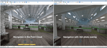
The Immersive Image Explorer fuses captured imagery with LiDAR point clouds, enabling professionals to virtually “walk through” their scanned environments inside LP360. Whether collected from aerial, mobile, or handheld TrueView systems, imagery can now be overlaid directly behind point clouds for a richer, more intuitive exploration experience. The Immersive Image Explorer is also compatible with DJI L2 datasets.
“With the Immersive Image Explorer, our customers can step directly into their datasets, navigating captured environments as if they were on-site, while maintaining the accuracy and qualitythat LP360 is known for,” said Frank Darmayan, CEO of GeoCue. “It’s about bringing clarity, speed, and confidence to every project.”
Flexible Image Options
The Immersive Image Explorer supports both frame images imported directly from the integrated cameras on aerial, mobile, or handheld TrueView hardware, as well as fully 360° spherical images collected with the TrueView GO 360 Photo Kit or the FLIR LadyBug camera for mobile mapping. No matter which format is used, the Immersive Image Explorer gives you the ability to pan, scan, and evaluate your photos directly within LP360, ensuring every detail of your project can be examined with clarity and precision.
A New Dimension in LP360 Visualization
The Immersive Image Explorer can be found within the Immersive View Window in LP360. The Immersive View Window is now the fourth main visualization option in LP360, joining Map View (2D), 3D View (isometric), and Profile View (cross-sectional).
Rather than replacing these views, the Immersive View Window complements them by combining many of their core capabilities into a single, intuitive interface. It allows users to view, navigate, and analyze their 3D data from multiple angles in real-time. Within this environment, the Immersive Image Explorer unlocks the ability to overlay imagery directly onto point clouds, seamlessly merging photos and LiDAR into a unified, immersive perspective.
Key Capabilities
Handheld Advantage – Merge imagery from TrueView GO’s three cameras with dense point clouds for detailed indoor and close-range visualization.
Aerial Integration – Seamlessly incorporate images from TrueView aerial payloads to provide context-rich overviews of larger sites.
Immersive Deliverables – Create a “street view” style navigation of your own data, fully measurable and directly inside LP360.
Flexible Image Sources – Works with frame images from integrated TrueView cameras or 360° spherical imagery captured by the TrueView GO 360 Photo Kit or FLIR LadyBug camera for mobile mapping.
Transforming Workflows Across Industries
From confined interior corridors to expansive construction sites, the Immersive Image Explorer empowers surveyors, AEC professionals, and public safety teams to work more effectively. It allows users to verify coverage and spot potential gaps before ever leaving the job site, ensuring confidence in their datasets. By merging real-world imagery with LiDAR, inspection and validation workflows become faster and more accurate, giving teams a deeper understanding of their projects.
“The Immersive Image Explorer is more than a viewer, it’s a smarter way to navigate, validate, and present geospatial data,” added Vivien Heriard Dubreuil, CEO of mdGroup, GeoCue’sparent company. “By combining imagery and LiDAR in one immersive environment, we’re enabling professionals to work faster, communicate better, and deliver more value to their clients.”
With Immersive Image Explorer, LP360 continues to evolve as the industry’s most complete platform for LiDAR and imagery workflows, putting users directly inside their data with clarity and precision.
To learn more about GeoCue, visit www.geocue.com.
You can skip to the end and leave a response. Pinging is currently not allowed.
Read the full article here